
From Detection to Reporting: Structuring Operational Evidence for Faster Decisions
The value of drone-enabled monitoring is realised only when observations are converted into usable operational outputs. Images, detections, location data, and sensor-linked observations must be structured into reports, alerts, audit trails, and decision... READ MORE

Satellite Data and Local Sensors: Building a Multi-Layered Operational Picture
Drone operations become more valuable when they are combined with other information sources rather than used in isolation. Satellite imagery, fixed sensors, and field-based data sources can provide broader coverage, earlier indications, and... READ MORE
Change Detection in Critical Infrastructure: Comparing Repeated Surveys for Early Warning
In many operational environments, the central question is not simply what a site looks like, but what has changed since the last inspection. By comparing repeat surveys over time, operators can identify gradual... READ MORE

Pipeline Monitoring and Corridor Inspection: Detecting Change Across Linear Infrastructure
Pipelines and other linear assets require inspection across long corridors where access can be difficult and where change may occur gradually. Drone-based corridor inspection supports repeatable observation of terrain movement, erosion, vegetation encroachment,... READ MORE

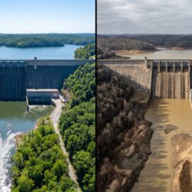
Dam Safety and Waterway Monitoring: Drone-Derived Evidence for Inspection and Maintenance
Dams, embankments, spillways, channels, and other managed water assets require regular inspection to identify structural wear, erosion, vegetation growth, sediment-related developments, and signs of local instability. In many cases, these inspection needs extend... READ MORE

Cross-Sector Drone Service Delivery: Patterns, Principles, and Scalability
The preceding articles have explored drone-enabled services across multiple sectors: maritime, construction, forestry, transport, energy, telecommunications, healthcare, agriculture, and public safety. Across these diverse applications, common patterns emerge in how services are structured,... READ MORE

Conferences, Knowledge Sharing, and Professional Development in Drone Operations
The drone sector is evolving rapidly, with new technologies, regulatory frameworks, and operational practices emerging continuously. Conferences, knowledge-sharing events, and professional development programmes play an important role in keeping practitioners current, connecting the... READ MORE

Software Platforms and Apps for Drone Operational Management
Operational drone services depend on software platforms for mission planning, fleet management, data processing, and integration. The software layer is where operational procedures are implemented, governance controls are enforced, and data flows between... READ MORE
Partners
![]()
![]()
![]()
![]()
![]()
![]()
![]()

![]()
![]()
![]()

![]()
![]()
![]()
Network
![]()